- Solve real problems with our hands-on interface
- Progress from basic puts and calls to advanced strategies
Interactive Options Course
Posted August 11, 2026 at 12:41 pm
Live Hurricane Prediction Markets at ForecastEx offer a new level of granularity for information discovery and risk transfer in the immediate lead-up to a storm’s landfall.
Hurricanes are among the most socially and financially consequential of all weather phenomena, accounting for nearly 40% of insured losses from natural hazards (SwissRe).
Last year, ForecastEx introduced Forecast Contracts on seasonal hurricane activity, including basin-wide storm counts and regional major (Category 3+) hurricane landfall contracts at various levels of granularity that resolve at the end of the year.
The basin-wide storm count contracts serve the purpose of broad information (how does overall hurricane risk this year compare to other years?), while the major hurricane landfall contracts at the geographic level of the US county have substantial hypothetical value as risk-hedging and risk-transfer tools.
On this risk hedging and risk transfer point, these major hurricane landfall contracts can still be improved on at least four dimensions
All four issues are addressed in ForecastEx’s just-released “Live Hurricane” contracts.
These contracts are tied to individual named storms as they happen, resolving questions of the form:
“Will Hurricane Julia cause wind gusts of 100 mph or greater in Miami, FL?“
ForecastEx will list these contracts after a hurricane forms, receives a name, and begins to legitimately threaten predetermined coastal locations (see below). The contracts will trade continuously as forecasts evolve, and they will resolve definitely, not at the end of the year, but within a few days of the storm’s dissipation.
Each Live Hurricane contract is defined by three parameters: a named storm, a location, and a wind threshold. There is also a complementary event question that asks which location will experience the highest winds from a given named storm.
The contracts reference 163 predefined locations representing recognizable coastal population centers or points of interest across the U.S. Gulf and Atlantic coasts, the Caribbean, Mexico, Central America, and northern South America (listed here).

Fig. 1 | Map of the live hurricane ForecastEx reference locations. These central locations and the size of the surrounding area are articulated in the location file published here. Figure produced by Patrick Brown with Matplotlib.
Defining markets around a manageable number of predefined discrete locations is intended to pool participant interest and thus market volume and liquidity, facilitating trading.
Each location is centered at a particular latitude and longitude and has an area surrounding it where winds can count toward resolution for that location. The area around each central point constitutes a 10 km radius applied to a discrete 1 km × 1 km pixel grid including only land pixels.
Below are visualizations of some locations and the size of the footprint for which winds count towards resolution.

Fig. 2 | Settlement areas for two hurricane-prone metro areas in Florida: Tampa Bay (left) and Miami (right). Each location settles on the maximum 3-second gust across the 1 km × 1 km land cells within 10 km of its reference point. Figure produced by Patrick Brown with Reask data and plotted with Matplotlib.
For each location in play, contracts are listed on a ladder of wind-gust thresholds: 70 mph or greater, 80 mph or greater, and so on in 10-mph increments, up to 200 mph or greater.
As with all ForecastEx Forecast Contracts, the price at any moment maps directly onto the market’s implied probability that the threshold will be met or exceeded, so the full ladder gives a sense of not just whether a location will be hit, but also the full likelihood distribution of intensity.
In addition to markets for the wind gust intensity magnitude at given locations above, ForecastEx will offer markets for which location, out of a defined pool, will eventually record the highest wind gust from the storm. This framing essentially drills down on the uncertainty in the storm’s path rather than uncertainty in the storm’s absolute wind intensity.
Contracts for a location and threshold are only listed once forecast data indicates a meaningful probability (around 5%) that the location will experience 70 mph or greater wind gusts from a storm that has formed and has been named by the World Meteorological Organization. When a storm is farther from the coast, more locations at lower probabilities may be in play, but the picture will generally sharpen as the storm moves closer.
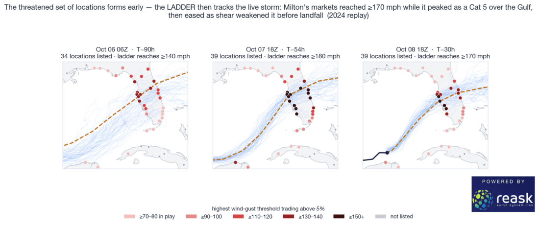
Fig. 3 | Evolution of highest wind gust threshold with meaningful probability in a replay of Hurricane Milton in 2024. Figure produced by Patrick Brown with Reask data and plotted with Matplotlib.
As the storm’s life comes to an end, the National Hurricane Center will issue its final advisory and the settlement value will be published on the ForecastEx website here.
The settlement value is the single maximum calculated 3-second wind gust experienced in each location’s footprint over the entire course of the storm. If the value meets or exceeds a contract’s defined wind gust threshold at a location, the contract resolves YES on that threshold.
Reask, a tropical cyclone risk analytics firm whose data underpins parametric insurance triggers across the global market, will serve as the resolution source via their Metryc product. The decision to resolve based on Reask calculations is international and driven by several factors.
First, to back up for a moment, the simple, intuitive way to settle a wind contract is to use an anemometer. For example, a contract could settle based on airport weather station anemometers. The problem with that is that physical instruments have a well-documented tendency to fail precisely during the events these contracts are meant to measure, because power is lost, a communication link is damaged, or the instrument itself is destroyed. Airport observing stations in particular regularly go dark during major hurricanes, and post-storm analyses are routinely forced to note that the highest winds likely occurred after the instruments stopped reporting. A settlement source that systematically disappears during the peak of the storm is obviously not fit for purpose for contracts like these.
Alternatives from sources like the National Hurricane Center’s Tropical Cyclone Reports carry authority but are unsuited for settling contracts like these because they are published many months after the storm and they are not standardized. They are narrative documents that compile whatever observations survived, at whatever points instruments happened to be present, in formats that vary from storm to storm.
Reask solves both reliability and timeliness issues with what they describe as virtual anemometers. Reask essentially calculates peak wind gusts for every 1 km × 1 km grid cell the storm affects, using the storm’s officially observed track and intensity, along with the known physics of how tropical cyclone wind fields interact with the specific topography and surface roughness of the land.
Crucially, the virtual anemometer cannot lose power or be blown away. Using Reask allows these contracts to reflect our best estimate, based on the available observations, remote sensing, and known physics, of what actually happened at the location. This is the same reason the parametric insurance market adopts calculations like those produced in Metryc for payout triggers.
Reask also calculates pre-event probabilities with a forecasting system called LiveCyc. LiveCyc generates on the order of a thousand plausible wind-field realizations for an approaching storm, conditioned on the National Hurricane Center forecast, and, from them, computes the probability that each location exceeds each threshold.
ForecastEx will publish these location-level LiveCyc exceedance probability forecasts on its website as they are produced from Reask (here), so every participant has access to the same institutional-grade probabilistic baseline that, until now, was available only to institutions paying for it.
Reask’s core methodology is well documented in peer-reviewed publications here, here, here, and here (see bibliography below).
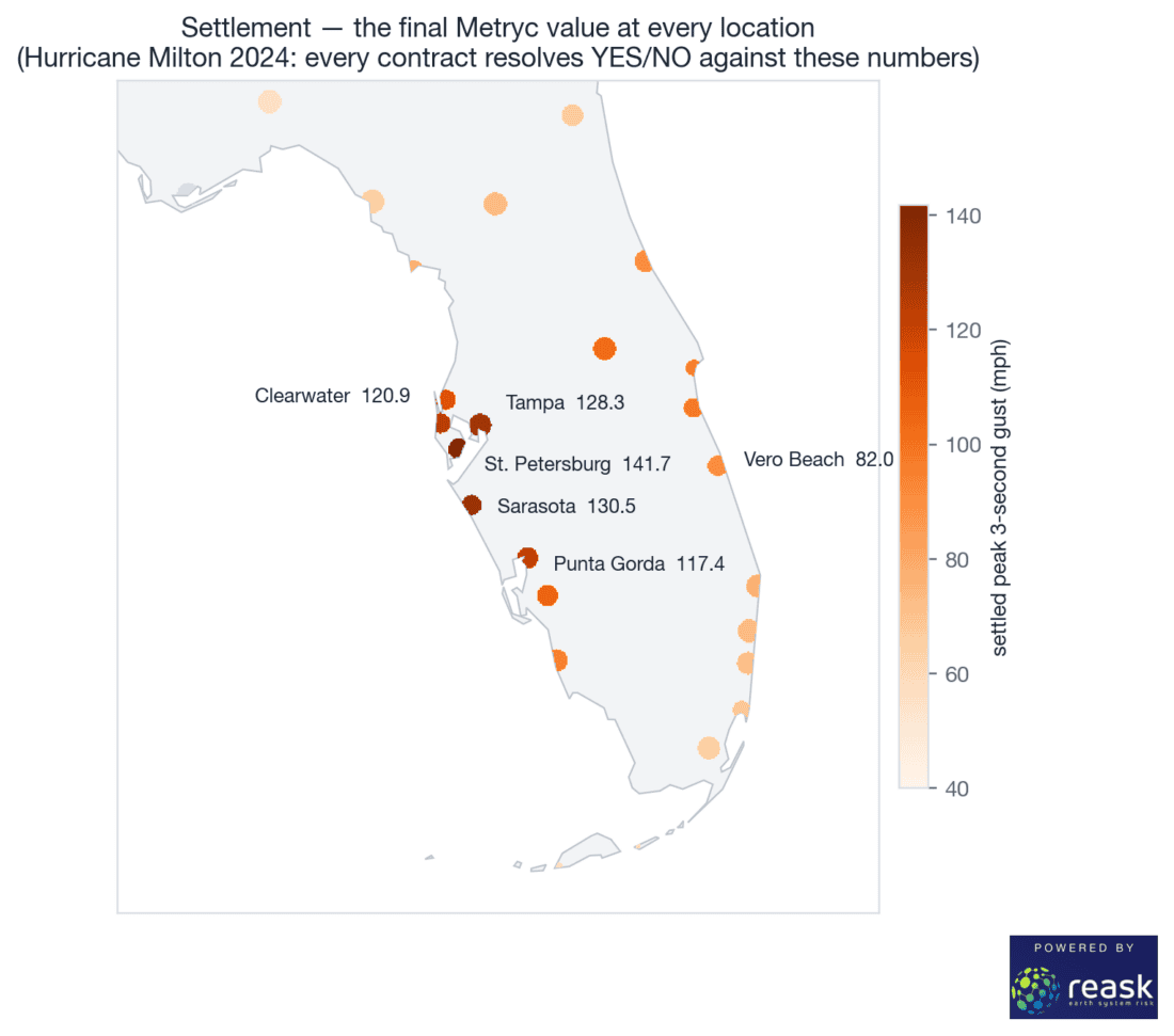
Fig. 4 | Settlement values for Hurricane Milton (2024) at reference locations in Florida. The virtual-anemometer approach yields a complete, consistent number for every location, and every listed contract resolves YES/NO against these values within days of the final advisory. In the case of the ‘where will the storm hit hardest’ version of the contract, St. Petersburg would have resolved YES and all other locations would have resolved NO. Figure produced by Patrick Brown with Reask data and plotted with Matplotlib.
These contracts settle on the local 3-second peak gust, not the 1-minute maximum sustained wind used in the traditional Saffir-Simpson categories.
This is a deliberate choice based on the evidence that structural damage scales much more closely with 3-second gusts than with 1-minute sustained winds. Engineering design codes (e.g., ASCE 7-95) are organized around gusts because roofs are lost, windows break, and trees are blown down during the strongest few seconds of wind. Furthermore, the wind a building experiences depends strongly on local terrain and surface roughness, which is what a 1 km terrain-interacting calculation captures.
For a rough scale, the World Meteorological Organization’s tropical-cyclone conversion guidance (Harper, Kepert & Ginger 2010, WMO TD-1555) suggests a 3-second gust is roughly 25% to 40% higher than the 1-minute sustained wind over land.
It should also be noted that the 1-minute maximum sustained wind that is the basis for the storm’s assigned Saffir-Simpson category is the storm-wide maximum, which typically represents just a small patch over the ocean in one section of the eyewall and will often be highly unrepresentative of the winds experienced at any given location during landfall.
In addition to their risk hedging use cases (see series of writings listed at the bottom of this article), these markets have the potential to be highly valuable from an information discovery perspective.
Based on accumulating evidence in both ForecastEx’s inaugural hurricane markets in 2025 and in ForecastEx’s temperature markets, the probabilities visible from these markets may constitute the best available location-level hurricane wind forecasts available, better than any single source, including the excellent data underlying them.
The mechanism by which this is possible is that prediction markets can aggregate conventional forecast information as inputs and convert them into refined probabilities through direct financial rewards for accuracy and direct financial penalties for inaccuracy. This creates a dual effect of attracting accurate individuals and systems into the market while deterring those who are inaccurate. People or systems that consistently make poor forecasts are strongly motivated to either improve or leave the market.
Another advantage of prediction markets over traditional methods is their perpetually ‘live’ update frequency (as long as markets remain liquid).
The underlying hurricane forecasts from both the National Hurricane Center and Reask’s own LiveCyc forecasts are constrained to update only about every six hours and also embed latency of another six hours or so coming from the cadence and workflow of incorporating the forecasts from the canonical global numerical weather prediction models.
The status and expectations of a hurricane can change meaningfully within a six-hour window, so prediction markets are naturally more responsive to real-time observations and can produce extremely valuable changes in information in those gaps.
These temporal gaps are also where speculative traders will likely seek an edge. Along those lines, Reask’s LiveCyc forecasts (posted live on ForecastEx’s website here) are centered on the National Hurricane Center’s central track forecast (with physically simulated along / across-track and intensity spread).
The National Hurricane Center track forecast is very good, but it is one forecast, on a fixed schedule, and the National Hurricane Center, in its own 2025 retrospective, identified the Google DeepMind ensemble mean as having performed better on short-range track forecasts.
The bottom line for an interested trader is that the Reask LiveCyc probabilities represent extremely useful information for these contracts, but they are still anchored to a consensus baseline, updated only every six hours and thus leave substantial room for traders to find edges.
One motivation for designing contracts around ‘live’ hurricanes is that it mimics the ‘Live cat’ trading that reinsurers and specialist funds already engage in when a major storm is threatening.
In principle, the structure of these contracts allows for an alternative means for a (re)insurer to hedge or transfer acute live hurricane exposure, with a firm that is over-exposed at a given location buying Yes on the higher gust thresholds and institutions seeking risk premium buying No.
However, in the first iterations at least, exchange volumes are unlikely to be large enough for a reinsurer to lay off a meaningful share of risk using these contracts, so the most immediate value-add is not necessarily (re)insurance-scale risk hedging but rather bringing better price discovery to a previously opaque market.
In the existing live-cat market, Industry Loss Warranties (ILW) and short-dated retrocession are negotiated bilaterally through a small set of specialist brokers and trade over-the-counter (OTC).
These Live Hurricane contracts reproduce the timing and the real-time character of this existing ‘Live cat’ trading, but rather than happening in the shadows, the activity happens on an open, regulated exchange, where the price is continuously visible, and anyone who qualifies can take either side.
Thus, a broker, a reinsurer, or a smaller participant negotiating an over-the-counter trade as a storm approaches will now have open prices on wind-speed exceedances to anchor to. For a buyer of protection in particular, a visible, continuously updated market on an exchange serves to discipline the pricing of a much larger opaque market and can act as a check against being quoted too high.
New to Prediction Markets?
Open a Prediction Markets AccountThe analysis in this material is provided for information only and is not and should not be construed as an offer to sell or the solicitation of an offer to buy any security. To the extent that this material discusses general market activity, industry or sector trends or other broad-based economic or political conditions, it should not be construed as research or investment advice. To the extent that it includes references to specific securities, commodities, currencies, or other instruments, those references do not constitute a recommendation by IBKR to buy, sell or hold such investments. This material does not and is not intended to take into account the particular financial conditions, investment objectives or requirements of individual customers. Before acting on this material, you should consider whether it is suitable for your particular circumstances and, as necessary, seek professional advice.
The views and opinions expressed herein are those of the author and do not necessarily reflect the views of Interactive Brokers, its affiliates, or its employees.
Event Contracts are only available to eligible clients, 21 years and older, of Interactive Brokers LLC, Interactive Brokers Canada Inc., Interactive Brokers Hong Kong Limited, Interactive Brokers Ireland Limited and Interactive Brokers Singapore Pte. Ltd. ForecastEx Forecast Contracts on US election results are only available to eligible US residents.
Futures, event contracts, and forecast contracts are not suitable for all investors. Before trading these products, please read the CFTC Risk Disclosure. For a copy, visit our Warnings and Disclosures Page.
This is commentary on economic, political and/or market conditions within the meaning of CFTC Regulation 1.71, and is not meant provide sufficient information upon which to base a decision to enter into a derivatives transaction.
Interactive Brokers LLC is a CFTC-registered Futures Commission Merchant and a clearing member and affiliate of ForecastEx LLC (“ForecastEx”). ForecastEx is a CFTC-registered Designated Contract Market and Derivatives Clearing Organization. Interactive Brokers LLC provides access to ForecastEx Forecast Contracts for eligible customers. Interactive Brokers LLC does not make recommendations with respect to any products available on its platform, including those offered by ForecastEx.
Displayed outcomes and prices are based on real-time market sentiment from ForecastEx LLC, an affiliate of IB LLC, as well as other CFTC-registered DCMs, including Kalshi and CME. For more information, see ibkr.com/realfex Note: Real-time market sentiment updates are only active during exchange open trading hours. Updates to current market sentiment for overnight activity will be reflected at the open on the next trading day. This information is not intended by IBKR as an opinion or likelihood of a potential outcome.
Event Contracts are not available to clients of IBKR Canada.
Related Articles
















Join The Conversation
For specific platform feedback and suggestions, please submit it directly to our team using these instructions.
If you have an account-specific question or concern, please reach out to Client Services.
We encourage you to look through our FAQs before posting. Your question may already be covered!