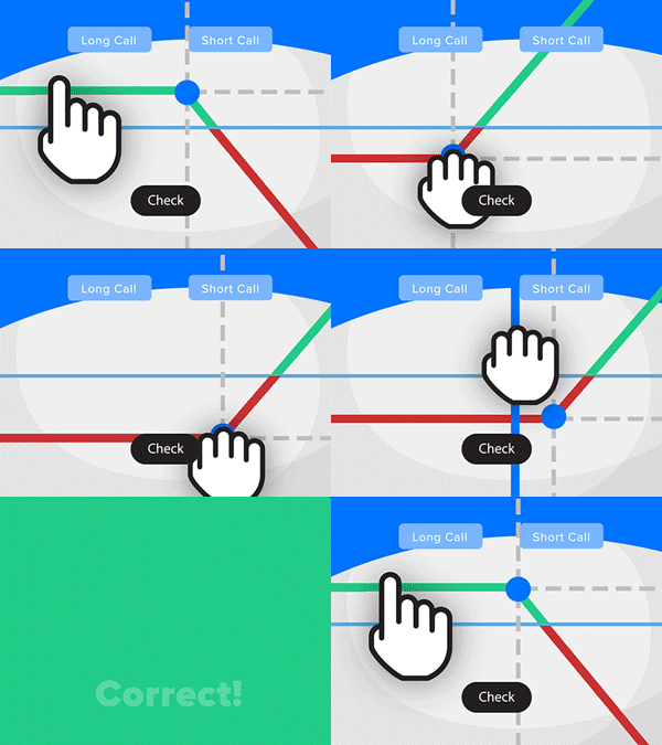
- Solve real problems with our hands-on interface
- Progress from basic puts and calls to advanced strategies
Interactive Options Course

Posted October 14, 2026 at 9:30 am
Hurricane Isaias marked the first time ForecastEx’s Live Hurricane contracts for an Atlantic hurricane progressed through the full life cycle, from storm formation to contract listing to settlement. All contracts settled shortly after landfall, with the peak gust registering at Fort Walton Beach at 144 mph.

Image from NOAA/NESDIS STAR (GOES-19 GeoColor, 5:30 PM CDT Friday, October 9).
The precursor thunderstorms of Isaias simmered for over a week in the southwestern Gulf, eventually organizing and becoming a named tropical storm on Wednesday, October 7. That night, the system crossed the Gulf toward the Florida Panhandle while strengthening into a hurricane. At 7:20 AM CDT on Friday, the system became a major hurricane with maximum sustained 1-minute winds of 120 mph, before weakening due to strong wind shear just ahead of landfall at 8:30 PM CDT Friday. The National Hurricane Center’s 4:00 PM CDT Friday discussion noted that it was “very likely that Isaias will be a gustier-than-normal hurricane when it makes landfall.”
ForecastEx’s Live Hurricane contracts ask questions of the form “Will Hurricane Isaias cause wind gusts of 100 mph or greater in Fort Walton Beach, FL?” Contracts are listed for a named storm once the tropical cyclone analytics firm Reask forecasts a meaningful chance, around 5%, of a gust of 70 mph or greater. Reask also serves as the settlement agency for the contracts.
For Isaias, ForecastEx listed 25 locations on Wednesday, October 7th. Nineteen were in Florida, and the others were Mobile, Gulfport, New Orleans, Brunswick, Savannah, and Río Lagartos in Mexico. Every location surfaced a 70 mph contract, and Pensacola, Fort Walton Beach, Panama City Beach, and Apalachicola had thresholds up to 110 mph. On Friday, after Isaias became a major hurricane, ForecastEx raised thresholds to 150 mph for Fort Walton Beach, 140 mph for Pensacola, and 120 mph for Apalachicola.
Bloomberg TV began displaying Live Hurricane probabilities from ForecastEx on Thursday, October 8th.

Screenshot of Bloomberg TV from the morning of Thursday, October 8th.
When Hurricane Isais made landfall at 8:30 PM CDT Friday, October 09 it was a Category 2 hurricane with 105 mph 1-minute maximum sustained winds.
However, these contracts settle on the highest 3-second gust that Reask calculates over the course of the storm because 3-second gusts better predict structural damage than the 1-minute sustained winds used to determine a hurricane’s Saffir-Simpson category.
The peak gust calculations at the most relevant locations are shown below.
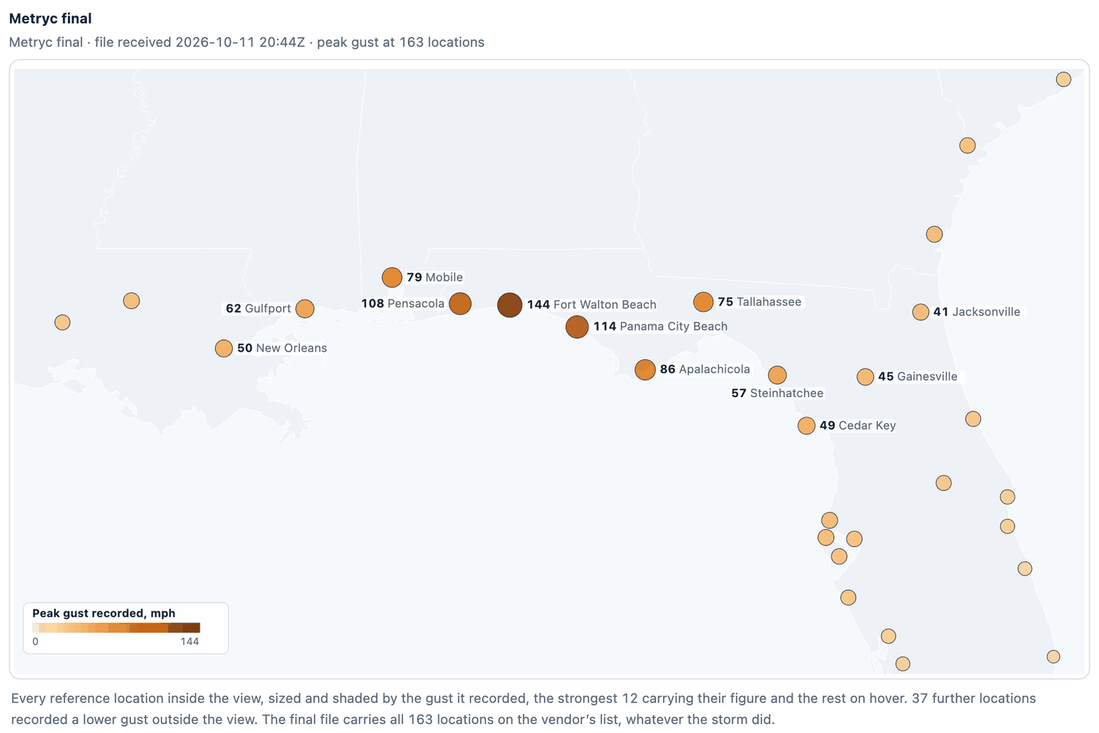
From the hurricane decision support page. The peak gust at each reference location in Reask’s Metryc product.
Reask calculated a 144 mph gust at Fort Walton Beach, which was 37% above the 105 mph 1-minute maximum sustained winds at landfall. However, World Meteorological Organization guidance (Harper, Kepert and Ginger 2010) indicates that 3-second gusts over land tend to be roughly 25% to 40% above the 1-minute sustained value, so this Fort Walton Beach gust falls within that range and is consistent with NHC’s expectation of a gustier-than-normal hurricane.
A companion contract also asked which location would record the storm’s highest gust. Fort Walton Beach became the favorite over the field late Thursday and never relinquished it.
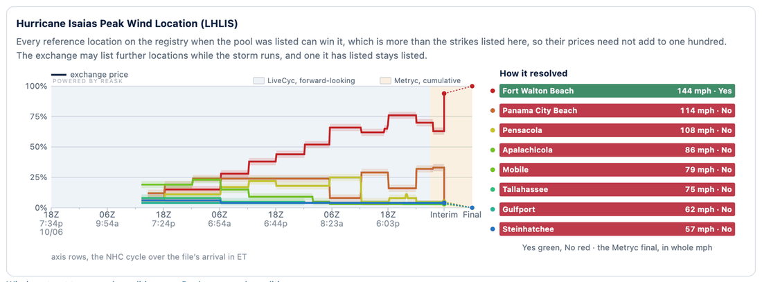
From the hurricane decision support page. The exchange price for each location on the peak wind location contract. Powered by Reask
A major feature of Reask’s virtual anemometer method is that it can fill in missing information even when instruments fail or stop reporting.
According to airport records archived by the Iowa Environmental Mesonet, the weather station at Hurlburt Field, about 7 km from Fort Walton Beach’s reference point, sent no reports during the storm’s peak, from 5:10 PM CDT Friday until 2:55 AM Saturday. Similarly, the station at Naval Air Station Pensacola, 12 km from Pensacola’s reference point, sent no reports from 4:56 PM to 10:49 PM. Those failures make anemometers unacceptable for settling contracts with money riding on them and demonstrate the necessity and value of a calculation methodology like Reask’s.
Given that this was the inaugural test of the Live Hurricane contracts and most potential participants were likely unfamiliar with them, expectations for initial trading volume were modest. That expectation held as the contracts traded, but only in small retail sizes. Trading was concentrated at six locations with some of the highest wind-speed probabilities (Fort Walton Beach, Panama City Beach, Apalachicola, Pensacola, Tallahassee, and Mobile) and in the hours leading up to and just following landfall.
However, each Atlantic storm is an opportunity to build familiarity and demonstrate the mechanics of these contracts so retail traders, market makers, and institutions feel comfortable trading them for future storms.
New to Prediction Markets?
Open a Prediction Markets AccountThe analysis in this material is provided for information only and is not and should not be construed as an offer to sell or the solicitation of an offer to buy any security. To the extent that this material discusses general market activity, industry or sector trends or other broad-based economic or political conditions, it should not be construed as research or investment advice. To the extent that it includes references to specific securities, commodities, currencies, or other instruments, those references do not constitute a recommendation by IBKR to buy, sell or hold such investments. This material does not and is not intended to take into account the particular financial conditions, investment objectives or requirements of individual customers. Before acting on this material, you should consider whether it is suitable for your particular circumstances and, as necessary, seek professional advice.
The views and opinions expressed herein are those of the author and do not necessarily reflect the views of Interactive Brokers, its affiliates, or its employees.
Interactive Brokers LLC is a CFTC-registered Futures Commission Merchant and a clearing member and affiliate of ForecastEx LLC (“ForecastEx”). ForecastEx is a CFTC-registered Designated Contract Market and Derivatives Clearing Organization. Interactive Brokers LLC provides access to ForecastEx Forecast Contracts for eligible customers. Interactive Brokers LLC does not make recommendations with respect to any products available on its platform, including those offered by ForecastEx.
Futures, event contracts, and forecast contracts are not suitable for all investors. Before trading these products, please read the CFTC Risk Disclosure. For a copy, visit our Warnings and Disclosures Page.
Event Contracts are only available to eligible clients, 21 years and older, of Interactive Brokers LLC, Interactive Brokers Canada Inc., Interactive Brokers Hong Kong Limited, Interactive Brokers Ireland Limited and Interactive Brokers Singapore Pte. Ltd. ForecastEx Forecast Contracts on US election results are only available to eligible US residents.
Displayed outcomes and prices are based on real-time market sentiment from ForecastEx LLC, an affiliate of IB LLC, as well as other CFTC-registered DCMs, including Kalshi and CME. For more information, see ibkr.com/realfex Note: Real-time market sentiment updates are only active during exchange open trading hours. Updates to current market sentiment for overnight activity will be reflected at the open on the next trading day. This information is not intended by IBKR as an opinion or likelihood of a potential outcome.
This is commentary on economic, political and/or market conditions within the meaning of CFTC Regulation 1.71, and is not meant provide sufficient information upon which to base a decision to enter into a derivatives transaction.
Related Articles














Join The Conversation
For specific platform feedback and suggestions, please submit it directly to our team using these instructions.
If you have an account-specific question or concern, please reach out to Client Services.
We encourage you to look through our FAQs before posting. Your question may already be covered!