- Solve real problems with our hands-on interface
- Progress from basic puts and calls to advanced strategies
Interactive Options Course
![Where Are The Hurricanes? Prediction Market Update [9/10/2025]](https://www.interactivebrokers.com/campus/wp-content/uploads/sites/2/2025/09/sep_11_20-700x354.png)
Posted September 10, 2025 at 11:45 am
It’s the typical peak of the Atlantic Hurricane season, but the basin remains calm, and that’s tipping the prediction markets.
September 10th represents the typical peak of the Atlantic hurricane season.

From News6 Orlando
At this point in the year, there have usually been about 8 named storms (reaching at least ‘tropical storm’ status with winds of at least 39 mph) and 3 to 4 hurricanes (with winds of at least 74 mph). But 2025 is running below normal, with 6 named storms and only 1 hurricane so far.
As the climate warms, there are conflicting effects on hurricane activity. Warmer sea surface temperatures mean storms can draw more energy when they form, potentially making them stronger. However, the balance of evidence suggests that climate warming also creates a more hostile atmosphere for hurricane development, and 2025 to date might be a small example of this tug-of-war.
Sea surface temperatures in the Atlantic have been mostly above average and sufficiently high for hurricane development (typically, above 27°C (81°F) is required).
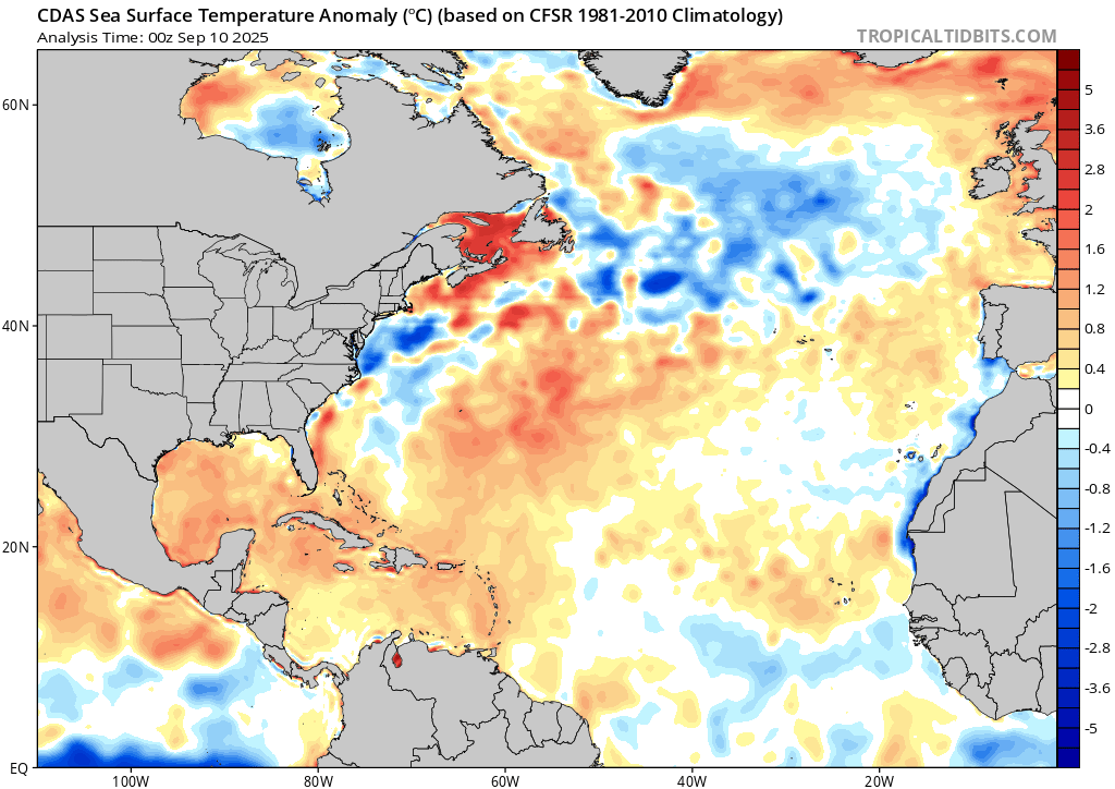
From Tropical Tidbits

From Tropical Tidbits
However, the atmosphere has not been particularly conducive to hurricane formation, either suppressing thunderstorms in various ways or providing too much wind shear for thunderstorms to grow into tropical storms and hurricanes.
The tide is not expected to turn in the immediate future, as the National Hurricane Center does not foresee tropical cyclone development within the next 7 days.

From the National Hurricane Center
Keep in mind that the criteria for a system to be a ‘tropical cyclone’ are quite inclusive: it’s any rotating system of thunderstorms with a closed low-level circulation that originates over tropical or subtropical waters. Tropical cyclones can thus be below the status of, and only potentially precursors to, named tropical storms, which are, in turn, below the status of, and only potentially precursors to, hurricanes.
Beyond the next week, the NOAA Climate Prediction Center forecasts that atmospheric conditions could become more favorable for tropical cyclone development by the latter end of September, with potential areas of development in the mid-tropical Atlantic and near the Yucatan Peninsula.

From the NOAA Climate Prediction Center.
This is consistent with the broad picture painted by ECMWF’s sub-seasonal model ensemble (run 100 times to assess probabilities) as well. Below is the probability of tropical cyclones passing within 300km (186 miles) of any point on the map for the week of September 15th through 22nd (top) and the week of September 22nd through 29th (bottom).
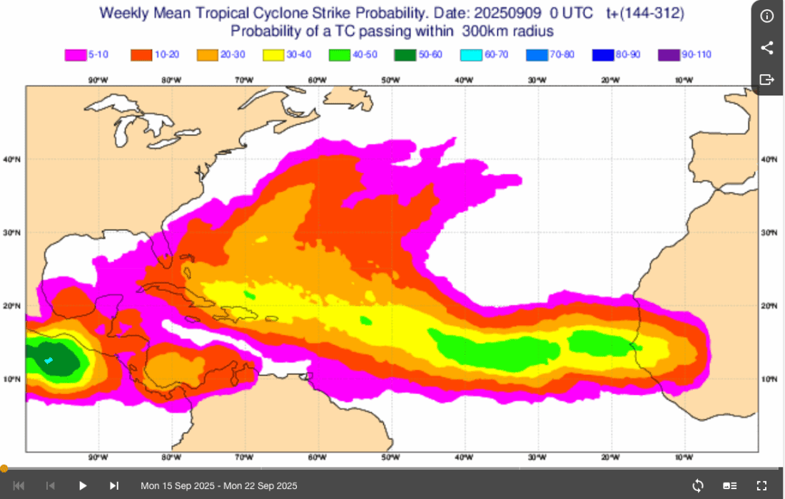

From ECMWF’s subseasonal tropical storm activity forecast.
Both of the above forecasts essentially call for a return to normal levels of tropical cyclone activity for that time of year, not necessarily above-normal tropical cyclone activity that would catch us back up to a typical hurricane season.
It is worth noting that Google DeepMind’s FNV3 probabilistic ensemble does indicate a tropical cyclone developing around Tuesday, the 16th, and possibly becoming a hurricane or even a major hurricane over the subsequent week (through Tuesday the 23rd).
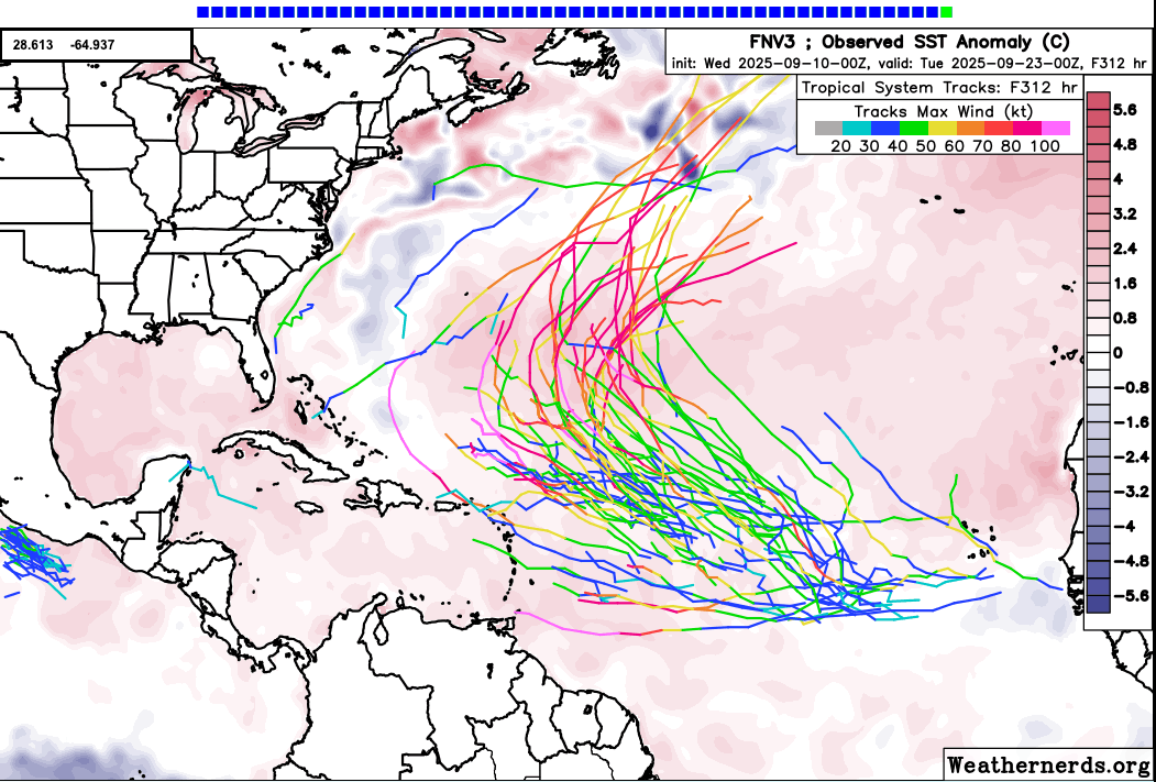
From Weathernerds
The average Atlantic hurricane season has 14 named storms (tropical storm status or higher) and 7 hurricanes.
Entering the 2025 Atlantic hurricane season, most traditional seasonal forecasts predicted above-normal hurricane activity because mild La Niña conditions were expected, and this is typically (though far from always) associated with atmospheric conditions conducive to hurricane formation in the Atlantic.
This sentiment was reflected in prediction markets as well.
In early August, Polymarket indicated that the chance of an active season (16-19 named storms) was much higher (44%) than an inactive season of less than 12 named storms (7%).
The recent lull in activity and relatively calm outlook have significantly moved the market in recent weeks and days, with the ‘16-19’ named storms category decreasing from 44% to 25%, and the ‘less-than-12’ category increasing from 7% to 24%.

From Polymarket
Similarly, Kalshi’s markets previously called for an above-average number of hurricanes (9+) but are now indicating a count well below normal at around 5.
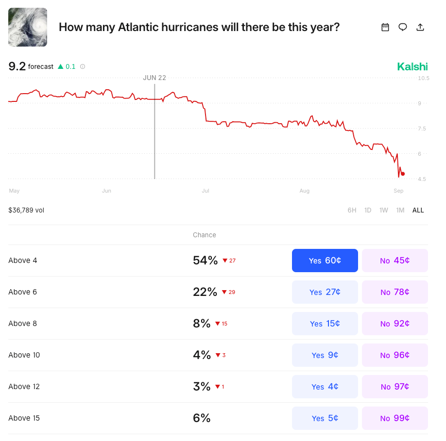
From Kalshi
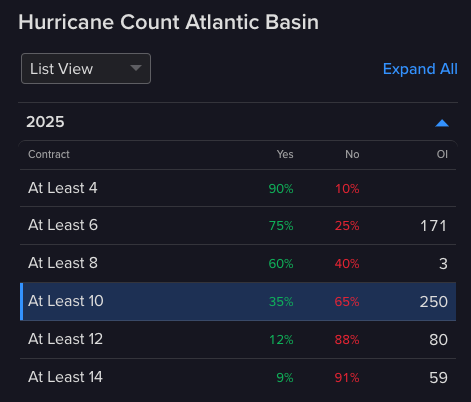
ForecastEx’s prediction markets are newer and thus have less participation than Polymarket or Kalshi at this point. Initially, ForecastEx’s markets also mirrored the traditional seasonal forecasts of above-average activity. However, these prices have yet to move as much as those in Polymarket or Kalshi, and, for example, are still indicating a 60% chance of 8 or more hurricanes.
From ForecastTrader
These numbers are rapidly becoming inconsistent with what has been observed to date.
To illustrate, consider the following simple calculation. Below is the typical cumulative count of hurricanes in the Atlantic, shown in black, with the range from 1950 to 2024 displayed in grey. Laid on top of that is a simple projection of 2025 in red. Given the above National Hurricane Center outlook, it assumes that Hurricane Erin remains the only named storm of 2025 until at least September 17th. The pink distribution represents plausible year-end totals and is created by taking the remainder of the count trajectories from September 17th going forward and appending them to the observed count (one) on September 17th. It thus assumes a climatologically normal remainder of the year (not a recovery).

From NOAA HURDAT2 Data processed and plotted in Matlab.
Based on this range of trajectories going forward, I can calculate the probability of breaching the defined count thresholds shown above in ForecastEx’s market. This simple calculation suggests that the current market probabilities for YES are too high and those for NO are too low.
Thus, there seems to be an opportunity emerging to obtain some good value in ForecastEx’s market by purchasing NO contracts at these prices. This might be particularly attractive to traders at Polymarket and Kalshi who are not seeing as clear examples of mispricing in those markets.
The analysis in this material is provided for information only and is not and should not be construed as an offer to sell or the solicitation of an offer to buy any security. To the extent that this material discusses general market activity, industry or sector trends or other broad-based economic or political conditions, it should not be construed as research or investment advice. To the extent that it includes references to specific securities, commodities, currencies, or other instruments, those references do not constitute a recommendation by IBKR to buy, sell or hold such investments. This material does not and is not intended to take into account the particular financial conditions, investment objectives or requirements of individual customers. Before acting on this material, you should consider whether it is suitable for your particular circumstances and, as necessary, seek professional advice.
The views and opinions expressed herein are those of the author and do not necessarily reflect the views of Interactive Brokers, its affiliates, or its employees.
Interactive Brokers LLC is a CFTC-registered Futures Commission Merchant and a clearing member and affiliate of ForecastEx LLC (“ForecastEx”). ForecastEx is a CFTC-registered Designated Contract Market and Derivatives Clearing Organization. Interactive Brokers LLC provides access to ForecastEx Forecast Contracts for eligible customers. Interactive Brokers LLC does not make recommendations with respect to any products available on its platform, including those offered by ForecastEx.
This is commentary on economic, political and/or market conditions within the meaning of CFTC Regulation 1.71, and is not meant provide sufficient information upon which to base a decision to enter into a derivatives transaction.
Related Articles


Join The Conversation
For specific platform feedback and suggestions, please submit it directly to our team using these instructions.
If you have an account-specific question or concern, please reach out to Client Services.
We encourage you to look through our FAQs before posting. Your question may already be covered!