- Solve real problems with our hands-on interface
- Progress from basic puts and calls to advanced strategies
Interactive Options Course
Posted September 28, 2026 at 12:34 pm


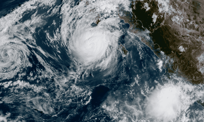
Image from NOAA STAR (GOES-West GeoColor, 11:40 AM EDT September 28).
The nor’easter that brought major tidal flooding to the Jersey Shore this weekend is winding down, and Hurricane Polo is about to make landfall in Baja California Sur.
This weekend’s nor’easter’s largest impacts were related to coastal flooding, which was some of the worst in the area since Hurricane Sandy (see The Eyewall‘s Sunday evening post for a recap of the meteorology).
ForecastEx’s measure of intensity, however, was the daily maximum wind speed contracts, which ask questions of the form “Will the maximum wind speed or wind gust in Nantucket exceed 59 mph on September 26, 2026?”
At the 14 stations with ForecastEx wind contracts, the largest gust was 62 mph at Nantucket at 2:53 AM Saturday, followed by 55 mph at Atlantic City late Friday, 54 mph at Martha’s Vineyard and Islip early Saturday, and 53 mph at New London early Saturday and Boston Saturday evening.
The largest payout multiples were:
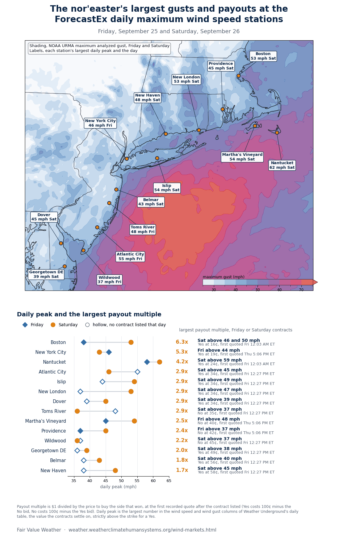
Shading from NOAA’s URMA analysis.
In the late morning on Monday, Hurricane Polo was a Category 3 hurricane with 115 mph winds about 85 miles west-southwest of Cabo San Lázaro, Mexico, moving northeast at 10 mph. The National Hurricane Center expects the center to reach the Pacific coast of Baja California Sur this evening, cross the Gulf of California, and make a second landfall in Sonora on Tuesday morning as a weaker hurricane.
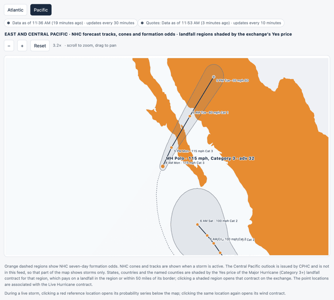
From the live hurricane page.
The relevant question for the ForecastEx hurricane landfall contract is whether Polo is still a major hurricane when its eye reaches the coast. The contract asks “Will there be a Major Hurricane Landfall within Mexico in 2026?” and settles on NOAA’s advisory at the time of landfall.
The Mexico landfall contract’s pricing fluctuated based on NHC’s forecast. It rose to 66% on Sunday afternoon (Yes bid 63¢, No bid 31¢) after NHC indicated Polo’s intensity near the coast increased to Category 3. Overnight, it reached 67%, then dropped to 32% early this morning (Yes bid 29¢, No bid 65¢) after the 5 AM ET forecast lowered the projected landfall intensity to about 95 knots. Later, it increased to 49% (Yes bid 46¢, No bid 48¢) following the 11 AM ET forecast, which kept Polo at 100 knots until landfall.

Figure produced by Patrick Brown with Matplotlib from ForecastEx prices and National Hurricane Center forecasts.
A Category 2 landfall would leave the contract open for the rest of the season. Tropical Storm Rachel, about 230 miles south-southwest of Acapulco, is forecast to become a hurricane on Wednesday and reach 100 mph by Thursday with a possible path on shore.
New to Prediction Markets?
Open a Prediction Markets AccountFutures, event contracts, and forecast contracts are not suitable for all investors. Before trading these products, please read the CFTC Risk Disclosure. For a copy, visit our Warnings and Disclosures Page.
Event Contracts are only available to eligible clients, 21 years and older, of Interactive Brokers LLC, Interactive Brokers Canada Inc., Interactive Brokers Hong Kong Limited, Interactive Brokers Ireland Limited and Interactive Brokers Singapore Pte. Ltd. ForecastEx Forecast Contracts on US election results are only available to eligible US residents.
Displayed outcomes and prices are based on real-time market sentiment from ForecastEx LLC, an affiliate of IB LLC, as well as other CFTC-registered DCMs, including Kalshi and CME. For more information, see ibkr.com/realfex Note: Real-time market sentiment updates are only active during exchange open trading hours. Updates to current market sentiment for overnight activity will be reflected at the open on the next trading day. This information is not intended by IBKR as an opinion or likelihood of a potential outcome.
This is commentary on economic, political and/or market conditions within the meaning of CFTC Regulation 1.71, and is not meant provide sufficient information upon which to base a decision to enter into a derivatives transaction.
Interactive Brokers LLC is a CFTC-registered Futures Commission Merchant and a clearing member and affiliate of ForecastEx LLC (“ForecastEx”). ForecastEx is a CFTC-registered Designated Contract Market and Derivatives Clearing Organization. Interactive Brokers LLC provides access to ForecastEx Forecast Contracts for eligible customers. Interactive Brokers LLC does not make recommendations with respect to any products available on its platform, including those offered by ForecastEx.
Related Articles

















Join The Conversation
For specific platform feedback and suggestions, please submit it directly to our team using these instructions.
If you have an account-specific question or concern, please reach out to Client Services.
We encourage you to look through our FAQs before posting. Your question may already be covered!